Friday, 27 April 2018

Evora, Portugal


The destruction of old Lisbon by the earthquake of 1755 left Evora as the finest example of a city that represents Portugal’s golden age. For that reason it became a UNESCO World Heritage site in 1986.
Evora lies about 70 miles east of Lisbon and has a population of around 35,000. 
The district was first settled by Celts before the Romans arrived and founded the city of Liberalitas Julia. Among Roman remains to be seen today is the well-preserved Temple of Diana. The amazing Agua da Prata aqueduct is not Roman but dates from somewhat later.
Traces can be seen of occupation by Visigoths and Moors, but the city was captured from the Moors in 1165, after which work started on the cathedral that replaced the earlier mosque.
Evora really came to prominence in the 15th century, when it became a favoured residence of Portuguese kings. This led to the building of convents, churches and palaces across the city.
The building craze continued into the 16th century, with notable buildings including the Palace of the Counts of Basto and the Church of the Knights of Calatrava. 

The above-mentioned Agua da Prata aqueduct was built in the 1530s. This was a project begun by King Joao III to improve Evora’s intermittent water supply by connecting the city to the Ribeira (River) do Divor 9 kms to the north. Much of the course consists of tunnels and channels, with arches (up to 26 metres high) only being necessary closer to the city. Work started in 1531 and took six years to complete. 

A notable feature of the aqueduct is the use made of the arches as side walls for houses and shops built soon after the aqueduct had reached the city.

The attractiveness of the architecture of Evora derives largely from the unity of style in the buildings from the 16th to 18th centuries, be they palaces or humble dwellings. Typical features include whitewashed walls, “azulejo” (ceramic tile) decoration and wrought iron balconies.

The city went into decline after 1759, when the Jesuits were expelled from the University of the Holy Spirit, but the buildings remain as monuments to Evora’s earlier prominence.

© John Welford

The Khami ruins in Zimbabwe


Many people know about Great Zimbabwe, the ancient city which gave its name to the country in which it is situated, but not so many have heard of Khami, which is just as remarkable in many ways.
The ruins of Khami are 23 km north-west of Bulawayo, the second largest city of Zimbabwe. Khami grew between 1450 and 1650 after the abandonment of Great Zimbabwe, some 250 kms to the south-east, and was the capital of the Torwa Dynasty for 200 years. There is evidence of occupation in the area from much earlier than 1450, including signs that the people were in contact with traders who visited from the coastal regions hundreds of miles to the east.
Like Great Zimbabwe, Khami comprised a stone-built complex of buildings and walls, with added features that derived from local building customs. The standard building method at Khami was to raise mounds, on which huts would be erected, and to surround the mounds with strong retaining walls, some of which produced a series of terraces. This differs from the Great Zimbabwe pattern, where the walls were free-standing and served to divide the area into compounds. The Khami walls were also more highly decorated than those at Great Zimbabwe, but it is clear that there were strong cultural connections between the two cities in terms of building techniques.
The most impressive walls surrounded the highest hill, which overlooked the river. This would have been the site of the king’s residence and those of his close circle. There are several hut platforms, terraces, and well-preserved stairways. The royal hut was reached by way of a covered passage. In 1947 a secret chamber was found that contained a number of royal possessions including axes, spears and items of carved ivory.
There have been many other interesting finds on the site, including what appears to be a Christian stone cross, possibly left by a Portuguese missionary, and boards for the game of Tsoro. A balanced boulder makes a sound like a gong when it is struck, and this could have been used to sound warnings or summon the people to gather together. Items discovered at Khami may be seen in the onsite museum and in Bulawayo’s Natural History Museum.
The whole site is about 40 hectares in size, and some 7,000 people may have lived in or near the city at its height. The people would have been farmers who both kept animals and grew crops. A great deal of trade was conducted, with metals including copper and gold being exchanged for goods brought by merchants from the coast. Some of these goods came from as far away as China and Spain.
It would appear that Khami was abandoned at the time of a civil war in the 1640s, during which a Torwa king was overthrown and appealed for help from the Portuguese, who sent an army to his aid. However, during the conflict the city’s mud and thatch huts were destroyed by fire and the Torwa were forced to leave Khami for good. The Rozwi kings who succeeded the Torwa established their bases at Naletale and Danamombe (formerly Dhlo Dhlo) near modern Gweru.
The Khami ruins are a UN World Heritage Site, and are therefore recognised as being of great archaeological importance. Although they have not received the same attention as those of Great Zimbabwe, anyone who is interested in the pre-colonial history of southern Africa should make a point of visiting them if they get the chance.
© John Welford

Wednesday, 25 April 2018

Great Zimbabwe: the city that defied colonial racism


Great Zimbabwe is a remarkable place. Situated in the south-east of the country that bears its name, it is a complex of stone structures that once formed the heart of a vast African empire. The ruins are notable for their extent (there are ruins across a total area of 500 square kilometres, or 200 square miles, but the main city comprises about 720 hectares) and the perfection of their construction. The walls were built using dry stone techniques, meaning that no mortar was used in their construction. Massive walls and towers still stand, more than 900 years after they were built, which is a huge tribute to the skill of their builders. Some of the walls still stand more than 30 feet high, are more than twenty feet thick, and are composed of granite blocks that fit together perfectly.

There is evidence that the site was first occupied as early as 500 AD, as it was high enough above the plains to avoid the ravages of the tsetse fly, which made life intolerable. The structures we can see today were begun in about 1100 AD, and the site was in constant occupation until about 1450 AD, when its occupiers moved away. At its height, the city of Great Zimbabwe was probably home to around 18,000 people, thus making it a major population centre, and there is evidence of a highly organized and developed civilization.

The site was unknown to the outside world until 1871, when a German geologist, Karl Mauch, came across the ruins. The controversy of Great Zimbabwe then started, because of disbelief that Africans could possibly have built anything so remarkable. To many whites, Africans were inherently inferior human beings who were incapable of creating anything as splendid as this.

Cecil Rhodes, whose colony of Rhodesia included the area of Great Zimbabwe, was also convinced that the city must have been built by white men, because of his unshakeable belief in the superiority of the white race. He was also convinced that the ruins contained buried treasure, and he set up a company, the Zimbabwe Ruins Company, to dig for the gold and diamonds, with no thought being given to the archaeological evidence that might be destroyed in the process.

Rhodes was followed by other Europeans who thought similarly, and some even claimed to have found the proof that the structures were not the work of Africans. The British archaeologist Richard Hall investigated the site in 1902, and asserted in his book “The Ancient Ruins of Rhodesia”, that it was built by “more civilized races” than the Africans. By digging down more than six feet and removing everything that was there to be found, he effectively destroyed all the evidence that countered his theory, even stating his aim as being to “remove the filth and decadence of Kaffir occupation”.

So, if Great Zimbabwe could not have been built by Africans, who did the imperialists think was responsible? They knew that no white Europeans had settled in this area, so they went for a candidate from the Old Testament instead, namely King Solomon. Karl Mauch was the first to suggest that this was the palace of the Queen of Sheba, who had famously visited Solomon and marvelled at his riches and splendour. He even detected, in one of the Zimbabwe buildings, a copy of Solomon’s Temple. Others thought that this was where the legendary King Solomon’s Mines must be, and the publication of Rider Haggard’s popular novel of that title, in 1886, did nothing to dispel this illusion, given his placing of the Mines in southern Africa. The implausibility of either Solomon’s wealth, or the Queen of Sheba, coming from a site some 4,000 miles from ancient Israel does not seem to have occurred to anyone at the time. Other theories included that the engineers had come from Portugal, China or Persia.

However, these views were challenged by two British archaeologists. In 1905, David Randal-MacIver gave his opinion that the dwellings on the site were “unquestionably of African origin”. This was virtual blasphemy to the imperialist rulers of the region, and no archaeologists were allowed to return for nearly 25 years.

When archaeology was once again permitted, in 1929, Gertrude Caton-Thompson, who led an all-female excavation, agreed with Randal-MacIver’s view. She used all the available evidence, including the oral traditions of the Shona people, to demonstrate that Great Zimbabwe must have been built by Africans. However, that did not stop the myth of Zimbabwe’s white origin from continuing. When Ian Smith declared, illegally, the independence of Southern Rhodesia with a minority white government, he had the history and guide books rewritten to show black Africans bowing in submission to the white builders of Great Zimbabwe.

Despite systematic efforts to destroy the evidence, it is now abundantly clear that the builders of Great Zimbabwe were the Shona people who settled in the area as long ago as 500 AD. Over time, they built an empire, known as Monomotapa, that covered most of modern Zimbabwe and Mozambique. Their wealth was based on trade, exporting gold, iron, copper, tin, cattle, and cowrie shells, and importing items including glassware from Syria, and Persian and Chinese ceramics. At the time of Great Zimbabwe’s discovery, there was considerable proof of this wealth in the form of items found on the site, but the looting of these treasures and destruction of archaeological evidence makes this less obvious today.

We also know that the Shona empire was powerful and wealthy enough to support a large city at its centre, and the size of the Great Zimbabwe site is itself evidence of this fact. Clearly this was not a city of white people, presumably descended from Solomon and Sheba, living in southern Africa for hundreds of years.

The empire of Monomotapa appears to have abandoned Great Zimbabwe in about 1450, although the empire itself continued to thrive. The reason for abandoning the site is not clear. Perhaps water supply became a problem, or maybe the Shona kings preferred to live in less austere surroundings than a massively fortified palace. Whatever the reason, they left behind a remarkable relic of their ancestors’ ability to build sophisticated structures that later colonizers could not believe were products of African skill and knowledge.

(See also: The Khami Ruins in Zimbabwe)

© John Welford

Tuesday, 3 April 2018

Thingvellir National Park, Iceland


Thingvellir National Park, in southwest Iceland, occupies more than 9200 hectares (35 square miles) of moorland, lakes and mountains. It is one of the country’s most popular tourist areas, but it also has great significance for its remarkable geographical features and historical connections that go back to the earliest days of human habitation in Iceland.


Geography

Iceland lies above the mid-Atlantic ridge, which is where the tectonic plates that carry America to the west and Europe to the east are slowly moving apart as new rock wells up from deep within the Earth’s crust. For nearly all its length the ridge is covered by the Atlantic Ocean, but it comes to the surface in Iceland and can be seen in Thingvellir National Park. The rift is clearly visible, as are cliffs of solidified magma that mark the western edge of the ridge.

The Park contains Lake Thingvallavatn, which is Iceland’s largest natural lake. The surface is 330 feet above sea level, but the water is up to 380 feet deep. 


History

Thingvellir means “meeting place of the people”. This was where the Althing met from 930 to 1798. This is the world’s oldest example of a representative parliament, meeting for a two-week period every year to decide on laws and conduct trials of lawbreakers.

It became the custom for people to treat the Althing as a much wider social event, with people gathering in their thousands from all over Iceland for purposes of trade, entertainment and cultural activity. Temporary dwellings were built to accommodate the attenders, and the remains of some of the huts can still be seen.

Thingvellir has acquired almost a mystical significance and is regarded by modern Icelanders as a very special place. 

© John Welford

Monday, 2 April 2018

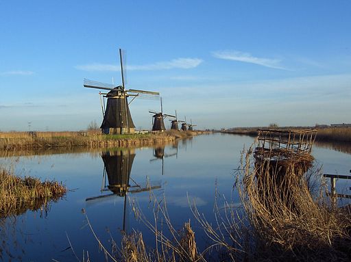
The windmills at Kinderdijk, The Netherlands


The windmills at Kinderdijk in the Netherlands are not only a beautiful and impressive sight as they stand, but they are also an important historical relic and testimony to the ingenuity of the Dutch people.
Land from the sea
The people of the Netherlands have a long history of creating farmland from what Nature intended should be the floor of the sea! Land reclamation began in about 1000 AD with the building of dykes (sea walls) to prevent the sea from inundating the low-lying land of Holland and Utrecht.
Efforts to drain marshland and create new farmland began in the 14th century with the digging of canals and regulation of the flow of water through a network of sluices and reservoirs. The new farmland proved to be fertile and peaty, and ideal for pasture and crop-growing.
However, the process of drainage behind the dykes caused the reclaimed land to sink below the level of the sea and therefore become subject to flooding from both the sea and the major rivers that flow through the region (notably the Rhine and its distributaries). A method was needed to lift excess water from the farmland (known as polder land) so that it could be deposited on the other side of the dykes.
Windmills as pumps
The Dutch did not invent the windmill (the Persians of the 9th century had that honour), but they must be credited for appreciating the potential of wind power to pump water in large quantities.
Windmills were erected in the Netherlands from the early 18th century to power rotary iron scoops that lifted water from the fields into reservoirs that were then emptied at low tide. Thousands of windmills were built, but they were gradually replaced by steam-powered pumps when the technology became available. However, some windmills still stand, and those at Kinderdijk are particularly impressive. 
The Kinderdijk World Heritage Site
The site, which is to the east of Rotterdam, consists of a network of dykes, reservoirs and pumping station as well as windmills. The district at one time boasted 150 windmills, but only 28 remain today, of which 19 are within the area covered by the World Heritage site. They were built between 1738 and 1740 and are kept in full working order, although their function as pumps has not been needed since the 1940s. They are, however, still available in reserve should the modern diesel-generated pumps break down.
The windmills that form such an impressive sight as they stand in a row are known as “ground sailers”, because their sails come to within 30 centimetres of the ground. The towers were built from brick and wood and most are of the “bonnet” design, which means that the top sections revolve in order to catch the wind.
The Kinderdijk windmills were declared a World Heritage site in 1997.
© John Welford